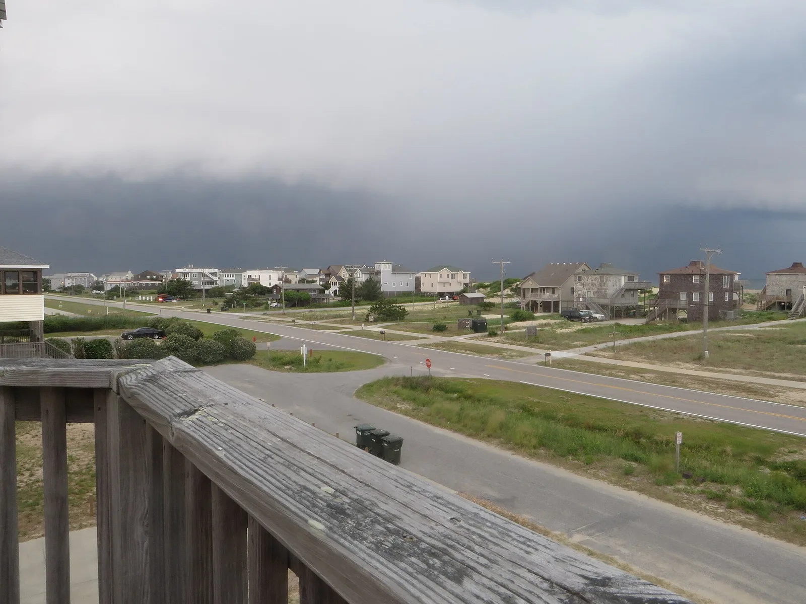
EF1 tornadoes touched down at Jordan Lake and in Cary on Oct. 11, the weather service found. Neither was in Holly Springs. Wind speeds, paths and the full storm log.
Two tornado warnings covered parts of western Wake County around midday Sunday. Weather service radar confirmed one tornado on the ground west of Apex. Storm reports logged trees snapped near Jordan Lake and a tree on a house on Cass Holt Road, south of downtown Holly Springs.
No tornado has been confirmed inside Holly Springs.
Updated Oct. 16: The National Weather Service has now surveyed both tornado reports nearest Holly Springs. Both were EF1 tornadoes, the second-lowest rating. The ratings and paths are in the new section below.
What the damage surveys found
The National Weather Service in Raleigh published its survey results on Tuesday, Oct. 13. They are preliminary until the agency’s final Storm Data review.
| Jordan Lake | Carpenter, Cary | |
|---|---|---|
| Rating | EF1 | EF1 |
| Peak wind | 107 mph | 100 mph |
| Path length | 1.07 miles | 0.37 miles |
| Maximum width | 50 yards | 50 yards |
| Time on the ground | 12:02 to 12:03 p.m. | 12:29 to 12:30 p.m. |
| Injuries | None | None |
Jordan Lake, Chatham County, about 10 miles west-northwest of Holly Springs. The tornado formed just south of Beaver Creek Road and snapped numerous trees. It crossed the road, then a small section of the lake, and lifted on the far shore about a minute later. The weather service credited the U.S. Army Corps of Engineers and Chatham County Emergency Management for photos and drone video.
Carpenter, Cary, about 11 miles north. The tornado formed near the West Regional Library on Morrisville Parkway, where it snapped a large tree in the parking lot. It moved northeast into the neighborhood north of the library, scattering snapped limbs. The survey found no structural damage. It said the strongest winds probably stayed in the treetops.
The same storms produced a third Wake County tornado, an EF1 with peak winds of 107 mph. It ran 2.51 miles in northeast Wake County, between New Hope and Rolesville, the survey found. It touched down in the Stone Ridge neighborhood, just south of Interstate 540, and lifted near Mitchell Mill Road.
The weather service’s EF scale puts EF1 winds at 86 to 110 mph.
The Cass Holt Road report, a tree on a house about four miles south-southwest of downtown, was logged as damaging wind. The weather service has not listed it as a tornado.
The rest of this story is as published Monday. The reports below were preliminary.
How the warnings unfolded
All times are Sunday, Oct. 11, from the warnings the National Weather Service in Raleigh issued.
| Time | What the weather service said |
|---|---|
| 11:06 a.m. | Severe thunderstorm warning for western Wake County and five other counties until 11:45 a.m., for 60 mph gusts. Fuquay-Varina and Angier were among the places named. |
| 11:52 a.m. | Tornado warning for southwestern Wake, northeastern Lee and southeastern Chatham counties until 12:15 p.m. A storm 9 miles southeast of Pittsboro showed rotation on radar. |
| 12:06 p.m. | A “radar confirmed tornado” was 9 miles east of Pittsboro, moving northeast at 20 mph. Cary, Apex, Jordan Lake and Carpenter were listed in its path. |
| 12:12 p.m. | New tornado warning for northwestern Wake, northeastern Chatham and southeastern Durham counties until 1 p.m. |
| 12:56 p.m. | Severe thunderstorm warning for all of Wake County and six others until 1:45 p.m., for 60 mph gusts. |
The 11:52 a.m. warning said the storm would stay over “mainly rural areas.” It named New Hill, Jordan Lake State Recreation Area and U.S. 1 between mile markers 78 and 98. The 12:06 p.m. update is in the weather service’s severe weather statement.
What was reported on the ground
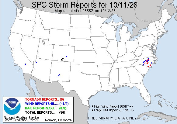
The Storm Prediction Center’s preliminary reports for Oct. 11 list these entries closest to Holly Springs:
- 11:42 a.m., Gum Springs Church Road, near Moncure in Chatham County: a large tree down on two power lines.
- 12:03 p.m., Beaver Creek Road, Chatham County, about 10 miles west-northwest of Holly Springs: a tornado report. “Numerous mature hardwood and pine trees downed… snapped and twisted on Beaver Creek Road… just south of Pea Ridge Road.” The report says the damage matched a tornado debris signature on radar.
- 12:05 p.m., the same stretch of Beaver Creek Road: several trees down, with both lanes blocked.
- 12:31 p.m., Cass Holt Road, about four miles south-southwest of downtown Holly Springs: a tree on a house, logged as damaging wind.
- 12:32 p.m., near Carpenter in Cary, about 11 miles north: a tornado report, with no further detail.
From 12:51 p.m., the reports moved to Raleigh, Rolesville and Wendell. Several there were also marked “possible tornado damage.”
How much rain fell
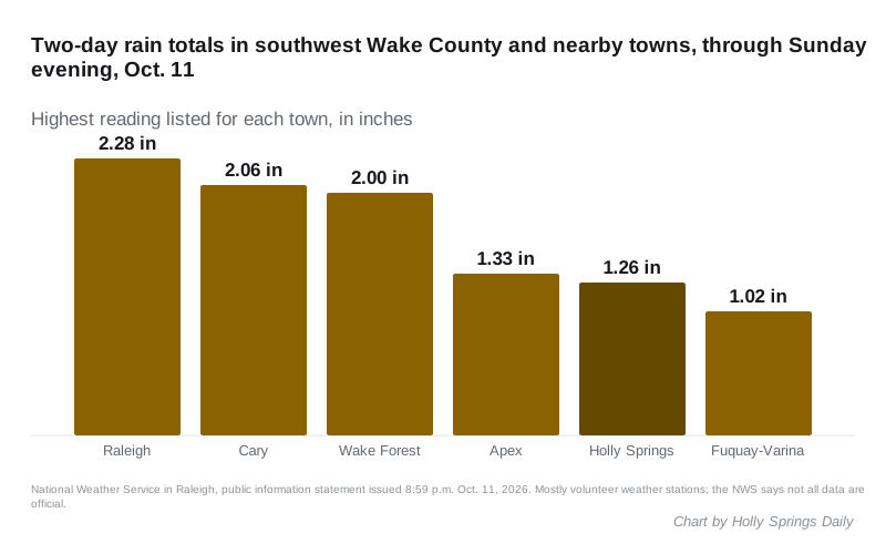
Two weather stations in Holly Springs recorded 1.26 inches and 1.01 inches over the two days to Sunday evening. That is less than Raleigh and Cary, where the highest readings topped 2 inches. The figures come from the weather service’s public information statement issued at 8:59 p.m. Sunday. Most are volunteer stations, and the weather service says not all of the data are official.
What it means for you
- The weather is clearing. The weather service forecast for Holly Springs calls for a mostly sunny Monday with a high near 82 degrees, then a sunny Tuesday near 86.
- Report damage. The weather service asks people to send storm damage reports through local law enforcement. For a tree on a town street, call the town at 919-577-3111. Duke Energy takes power outage reports; our power outages page has the numbers.
- The surveys are in. Both tornadoes nearest Holly Springs were rated EF1, as set out above. The weather service may still revise the figures in its final Storm Data review.
Have photos of storm damage in Holly Springs you are happy for us to publish? Email hello@hollyspringsdaily.com.
Have your say