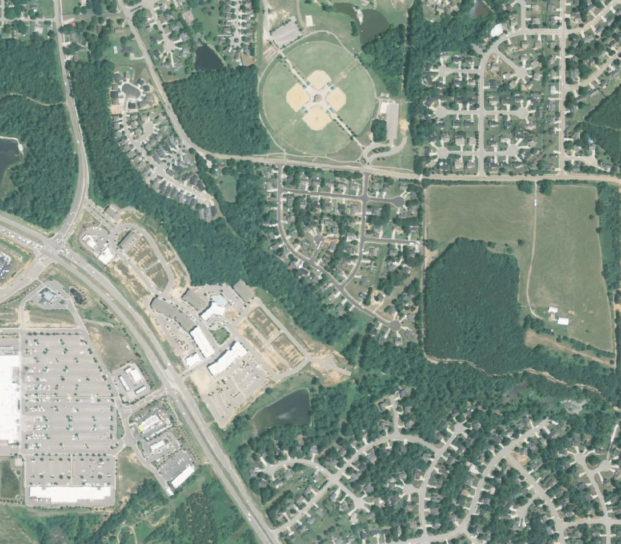
Main Street Square is south of downtown Holly Springs near South Main Street and the N.C. 55 Bypass, in ZIP code 27540, zoned for Herbert Akins Road schools.
Last checked Oct. 11, 2026. Sources: OpenStreetMap, the Town of Holly Springs’ parks pages and Vision Holly Springs Land Use and Character Plan, the Wake County Public School System’s base school lookup, the N.C. Department of Public Instruction’s 2025-26 accountability data, the U.S. Census Bureau’s TIGERweb town limits and Zillow Research.
Main Street Square is the area just south of downtown Holly Springs, between South Main Street, the N.C. 55 Bypass and Parrish Womble Park. OpenStreetMap names it as a neighborhood. It holds houses and townhomes on streets such as Kentworth Drive, Occidental Drive, Werrington Drive and East and West Maple Avenue, with a cluster of stores where South Main Street crosses the bypass. Every address here is in ZIP code 27540.
What this means for you
- Zoned high school: mostly Holly Springs High, 84.4% of state tests at grade level in 2025-26; two of eight addresses we checked were zoned for Fuquay-Varina High (73.5%), according to the state’s accountability data. Check an address with the district’s base school lookup.
- Home value: $577,082 in ZIP code 27540 in August 2026, according to the Zillow Home Value Index.
- Nearest freeway exit: N.C. 540 Exit 50 at Holly Springs Road, about 4 miles by road.
Part of our Holly Springs neighborhoods guide.
Where it is
Main Street Square sits about 0.9 mile by road south of Main and Ballentine streets. Womble Park, on Grigsby Avenue, borders it to the northeast, and the bypass, where stores carry G.B. Alford Highway addresses, runs along its southwest side. The town’s Land Use and Character Plan places a medical campus with a “seven-story community hospital” at N.C. 55 and Avent Ferry Road, just west of the bypass.
Town or county? We found 425 residential addresses within about a third of a mile of the place OpenStreetMap marks. On the Census Bureau’s TIGERweb map, 421 were inside town limits and four were not. See our property tax guide.
Schools
Main Street Square is in the Wake County Public School System. All eight addresses we checked in the district’s base school lookup for 2026-27 were zoned for Herbert Akins Road Elementary and Herbert Akins Road Middle, both on year-round calendars, at campuses with Fuquay-Varina addresses. Six, on Kentworth Drive, West Maple Avenue, Pine Orchard Court, East Maple Avenue and Spring Pine Lane, were zoned for Holly Springs High. Two, on Somerset Farm Drive and Weathervane Way, were zoned for Fuquay-Varina High. The high school line runs through the area, so check your own address.
Scores are the share of state tests at grade level or above in 2025-26 and the state’s growth rating, from the accountability data.
| Level | School | At grade level | Growth |
|---|---|---|---|
| Elementary | Herbert Akins Road Elementary, 2255 Herbert Akins Road, Fuquay-Varina | 72.9% | Met |
| Middle | Herbert Akins Road Middle, 2275 Herbert Akins Road, Fuquay-Varina | 68.7% | Exceeded |
| High | Holly Springs High, 5329 Cass Holt Road | 84.4% | Exceeded |
| High | Fuquay-Varina High, 201 Bengal Blvd., Fuquay-Varina | 73.5% | Met |
Four-year graduation rates were above 95% at Holly Springs High and 93.9% at Fuquay-Varina High. More in our schools guide.
Home values
Zillow publishes no figure for Main Street Square. The Zillow Home Value Index is a modeled typical value for the middle third of homes, not a sale price.
| Area | August 2026 | August 2025 | Change |
|---|---|---|---|
| ZIP code 27540 | $577,082 | $581,533 | -0.8% |
| Town of Holly Springs, for comparison | $574,699 | $579,299 | -0.8% |
Trends are on our home prices page, and recent sales on our real estate transfers page.
Parks and trails
- Parrish Womble Park, 1201 Grigsby Ave., has ballfields, a turf field, tennis courts, a playground and a band shell. It is open sunrise to sunset.
- The paved, 1.3-mile Carl Dean Greenway runs from Womble Park to Bass Lake Park, with six workout stations.
- Sugg Farm, 2401 Grigsby Ave., is 117 acres of pasture and woods with a dog park, a nature play area and the town’s festival grounds.
- Bass Lake Park, 900 Bass Lake Road, has a 1.9-mile lake trail and seasonal boat rentals.
More in our parks and trails guide.
Getting around
- N.C. 540: Exit 50 at Holly Springs Road is about 4 miles by road; Exit 54 at N.C. 55 is about 4.2 miles.
- Downtown Holly Springs: about 0.9 mile by road.
- RDU International Airport: about 24 miles by road.
- Buses: GoTriangle Route 305’s downtown stop, on Main Street between Ballentine and Center streets, is the closest, according to the town’s bus service page.
- Holly Springs Hopper: the town’s on-demand rides cover town limits, according to its Hopper page.
Distances were measured with the OSRM routing engine on OpenStreetMap roads. They are distances, not drive times. More in our getting around guide.
Groceries and everyday stores
OpenStreetMap lists a Walmart Supercenter at 7016 G.B. Alford Highway, an ALDI at 7400 G.B. Alford Highway, and a Harris Teeter and a CVS Pharmacy at 324 and 151 Village Walk Drive, all within about half a mile.
Frequently asked questions
Where is Main Street Square in Holly Springs?
South of downtown, between South Main Street, the N.C. 55 Bypass and Parrish Womble Park on Grigsby Avenue, about a mile by road from Main and Ballentine streets.
What schools serve Main Street Square in Holly Springs?
All eight addresses we checked for 2026-27 were zoned for Herbert Akins Road Elementary and Herbert Akins Road Middle, both year-round. Six were zoned for Holly Springs High and two for Fuquay-Varina High.
What is the typical home value in Main Street Square?
The area is in ZIP code 27540, where the Zillow Home Value Index was $577,082 in August 2026, down 0.8% from August 2025.
What park is near Main Street Square?
Parrish Womble Park, 1201 Grigsby Ave., with ballfields, a turf field, tennis courts, a playground and a band shell. The 1.3-mile Carl Dean Greenway runs from it to Bass Lake Park.
Have your say